Appenzell Ausserrhoden
| Kanton Appenzell Ausserrhoden | |||
|
|||
 |
|||
| Coordinates | |||
| Capital | Herisau (administrative) Trogen (judicial) |
||
| Largest city | Herisau | ||
| Population | 53,043 (12/2009)[1] | ||
| - Density | 218 /km² (565 /sq mi) | ||
| Area | 243 km² (94 sq mi) | ||
| Highest point | 2,502 m (8,209 ft) - Säntis | ||
| Lowest point | 430 m (1,411 ft) - Lutzenberg | ||
| Joined | 1513 | ||
| Abbreviation | AR | ||
| Languages | German | ||
| Executive | Regierungsrat (7) | ||
| Legislative | Kantonsrat (65) | ||
| Municipalities | 20 municipalities | ||
| Website | AR.ch | ||
| View map of Appenzell Ausserrhoden | |||
|---|---|---|---|
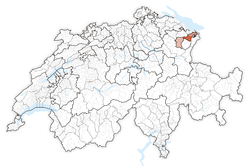
Appenzell Ausserrhoden (German: Appenzell Ausserrhoden; in English sometimes Appenzell Outer Rhodes) is a canton of Switzerland. The seat of the government and parliament is Herisau, judicial authorities are in Trogen. Appenzell Ausserrhoden is located in the north east of Switzerland, bordering the cantons of St. Gallen and Appenzell Innerrhoden.
Contents |
History
Settlement in Appenzell started in the 7th and the 8th century alongside the river Glatt. The monastery of St. Gallen is of great influence on the local population. In 907 Herisau is mentioned for the first time, the canton (Appenzell: abbatis cella) is named first in 1071. Starting in 1401, the combined canton of Appenzell rebelled against the bishop. Following a series of battles known as the Appenzell Wars, including the successful Battle of Vögelinsegg (1403) and the Battle at the Stoss (1405), Appenzell became independent of the Abbey. In 1513 Appenzell joined the Swiss confederation as the 13th canton. In 1597 the Protestant canton was divided for religious reasons from the former canton Appenzell, with the Catholic Appenzell Innerrhoden being the other half.
From the 16th century onwards linen production was established little by little. Larger textile businesses established themselves, later diversifying into weaving and embroidery. The textile industry collapsed between 1920 and 1939. In 1834 for the first time a constitution was adapted, undergoing reforms in 1876 and 1908. The construction of numerous railway lines between 1875 and 1913 helped the local industry and the population grew to a maximum of 57,973 people in 1910 (compared with 53,200 in 2001). In 1934 Johannes Baumann was the first citizen from Appenzell Ausserrhoden to become a federal councilor. Women's right to vote was introduced in 1972 on a local level, but only in 1989 on a canton-wide level. In 1994 for the first time two women were elected into government. The open assembly (Landsgemeinde) was abolished in 1997. The right of foreigners to vote is determined by each municipality.
Municipalities
The 20 municipalities (Einwohnergemeinden) are:
|
|
Demographics
The population of the canton is 52,654 (2007) of which 6,959 (13.22%) are foreigners.[2] Due to the split of Appenzell, the majority of the population (as of 2000[update]) is Protestant (51%) with a Roman Catholic minority (31%).[3]
See also
- List of castles and fortresses in Switzerland
External links
- Official Page (German)
- Official Statistics
 Media related to Canton of Appenzell Ausserrhoden at Wikimedia Commons
References
Notes
- ↑ Swiss Federal Statistical Office, MS Excel document – Bilanz der ständigen Wohnbevölkerung nach Kantonen, Bezirken und Gemeinden (German) accessed 25 August 2010
- ↑ Federal Department of Statistics (2008). "Ständige Wohnbevölkerung nach Staatsangehörigkeit, Geschlecht und Kantonen" (Microsoft Excel). http://www.bfs.admin.ch/bfs/portal/de/index/themen/01/02/blank/key/raeumliche_verteilung/kantone__gemeinden.html. Retrieved 2008-11-05.
- ↑ Federal Department of Statistics (2004). "Wohnbevölkerung nach Religion" (Interactive Map). http://www.bfs.admin.ch/bfs/portal/de/index/themen/01/05/blank/key/religionen.html. Retrieved 2009-01-15.
|
|||||

